What role can all the satellites launched for Nigeria play in efforts to prevent terrorism in the country and rescue the abducted schoolgirls and others still in captivity?
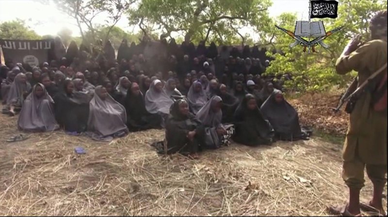
In April, 2014, there was the kidnap of 276 schoolgirls from Government Secondary School, Chibok, Borno State, northeast Nigeria, by Boko Haram terrorists.
Presidents, world leaders, United Nations Children’s Fund, UNICEF, condemned this act of terrorism while market women led protests across the country, demanding the immediate release of the girls.

The #BringBackOurGirls campaign that followed locally, quickly gained global support, creating awareness and also demanding the girls’ release.
Nigeria accounts for 20% of out-of-school children in the world.
Nigeria also has intermittent cases of communal violence like the ones in Benue and Kaduna states; banditry and cattle rustling particularly in the northeastern part of the country; farmers-herders clashes and religious crisis.
Nigeria’s first satellite, NigeriaSat-1, an Earth observation micro-satellite weighing 94 kilograms with a design life of five years, was launched on September 27, 2003. It cost the country 13 million US dollars.

On August 17, 2011, a replacement, NigeriaSat-2, a minisatellite weighing 286 kg, was launched. An equivalent satellite, NigeriaSat-X, built by Nigerian scientists and engineers from the National Space Research and Development Agency, NASRDA, was co-launched with NigeriaSat-2.
The cost of both satellites, is 30 million pounds, without launch and insurance, according to a BBC report. Wikipedia puts the final cost as 35 million pounds.
On May 13, 2007, the country’s first communications satellite, NigComsat-1, a large geo-stationary satellite weighing 5,150 kg (11,350 lbs), was launched at an overall cost of 300 million US dollars.
It developed a Solar Array Deployment Assembly problem and de-orbited on November 11, 2008 and a replacement, NigComsat-1R, was launched December 19, 2011, into same orbital slot of 42.5 degrees east, on the plane of the Equator.
This was at no extra cost to Nigeria from the contractors, China Great Wall Industry Corporation, CGWIC.
Nigeria EduSat-1, a nanosatellite weighing one kilogram, was launched on 3 June, 2017. It was designed and built by the Federal University of Technology, Akure, southwest Nigeria, for educational purposes.
A CubeSat, measuring 10 by 10 by 10 cm, the satellite was part of the Japanese Birds-1 constellation comprising four other CubeSats belonging to Japan, Ghana, Mongolia and Bangladesh.
It was launched by SpaceX on its CRS-11 mission to the International Space Station, ISS, using a Falcon 9FT, CRS 11 rocket from NASA’s Kennedy Space Centre, USA.
It was deployed into a Low Earth Orbit, LEO, of 400 km (250 miles) using Nanocracks CubeSat Deployer from ISS on 7 July, 2017.
It circled the Earth every 92.57 minutes, being a LEO satellite, and its telemetry was well-received by all members of the Birds-1 countries.
The entire cost of the project (building and launch) was half a million US dollars.
EduSat-1 de-orbited on 13 May, 2019.
On 22 December, 2022, a military satellite, DELSAT-1, was launched for the Defence Space Administration. It’s Ground Control Station was inaugurated on 20 December, 2022, in their Obasanjo Space Centre headquarters in Abuja. Only Egypt, Algeria, South Africa and Nigeria have military satellites in Africa. Details were not given, except that it is an integrated satellite, meaning that it can integrate or combine a satellite network with a terrestrial network and can, therefore, cover remote terrains without connectivity.
A common question is: What roles can Nigerian satellites, still in orbit, play in the fight against terrorism?

It is important to note that the role a satellite can play is not limitless. This is because the work a satellite does depends on the payload it is carrying. The payload is the cargo of equipment the satellite carries into space to do the work for which it is being launched.
Earth-observation satellites, like NigeriaSat-1, carry a payload of imagers or cameras that take pictures and send them down to the Control Station on the ground.
NigeriaSat-1, with its six imagers, had a Ground Sampling Distance, GSD, as spatial resolution is called in the satellite industry, of 32 metres.
By 2013, the two satellites had sent over 1,400 images. These images, apart from assisting in studies on flooding, erosion, deforestation, desertification etc, are also invaluable in planning security operations and emergency response.

A few Earth observation satellites with expensive, high resolution imagers are commonly used in espionage as well as in intelligence gathering in the fight against terrorism.
They do reconnaissance like communication eavesdropping, photo surveillance and radar imaging using synthetic aperture radar at night or through thick cloud cover to get clear pictures.
Five of such reconnaissance satellites were used to expose war crimes and human rights abuse in Sudan and South Sudan for nine months between 2012 and 2013 when the government there, it was said, refused humanitarian agencies access to rebel-controlled areas.
If countries that have these spy satellites, as they are called, like the United States, Russia and China, can avail Nigeria of their services, the location of the yet-to-be-found abducted Chibok girls and the others kidnapped later, like Leah Sharibu, can be clearly seen from the images and their kidnappers identified without their knowing it.
This is safer than flying noisy helicopters or other low-flying aircraft, or slow and conspicuous unmanned drones over their heads, annoying them and endangering the lives of the girls.
Earth observation satellites usually have an altitude of about 500 kilometres from the ground. Their orbits are mostly closer to the Earth than other satellites so that they can take clearer pictures.
NigeriaSat-1 had an altitude of 368 kilometres. Communications satellites have a higher altitude of approximately 36,000 kilometres.
It is therefore, impossible to know that any of these satellites is there, without sophisticated instruments, as they orbit and make a pass.
A band is a frequency range and a transponder is a satellite device that receives and relays or transmits signals it received back to Earth. It is useful in telecommunications, broadcasting, aviation, maritime, defence and security.
Some communications satellites, the so-called Search and Rescue satellites, are invaluable in search and rescue efforts, like for airplanes downed by terrorists and hijacked vessels or sinking ships and can be particularly useful in preventing terrorist attacks in schools.
Nigeria, through its National Emergency Management Agency, NEMA, is joined to the worldwide humanitarian COSPAS SARSAT satellite-based search and rescue programme which has satellites in Geo-stationary orbit, 35,786 kilometres away, and in Low Earth Orbit, LEO, about 500 kilometres from Earth.
Signals are more potent when the source is closer.
These LEO satellites in the constellation make a pass or orbit over every spot in the world up to 24 times a day.
The frequency of a pass is important to reduce the time a distress alert is made and received.

Emergency beacons, which are devices carried by airplanes and ships, are activated and transmit distress signals on harsh impact like in a plane crash; or when wet, as in a sinking ship, to the nearest satellite in the constellation.
The satellite on receiving the signal will transmit it to the nearest Local User Terminal, LUT, which are satellite dishes or antennae on the ground.
The LUT will immediately alert a Mission Control Centre, MCC, like NEMA, which informs a Rescue Control Centre, RCC, covering the area so that rescue operations can commence.
All these are done without wasting time going through the COSPAS SARSAT headquarters in Montreal, Quebec, Canada.

There are different types of emergency beacons and in some the distress alert can be activated or triggered-off manually, making them useful at times of maritime hijack and for missing campers.
There are over 600,000 emergency beacons in use in the world.
For a very long time, a common impression was that satellites are purely an ego thing.
The ordinary man however, started feeling he has something to gain, other than his country’s ego, from space science and technology since the launch of the first weather satellite, Tiros-1, carrying low-resolution television and infrared cameras in April, 1960 by America.

The US has 2,944 artificial satellites; China, 499; Russia, 169; Nigeria, 6; Morocco, 2; and North Korea, 2.
Today, the role of satellites, no doubt, seems to be better understood in the world but, it can be argued, it is still not fully appreciated.
Forbes in 2019 rated Nigeria, even in peace time, the third most dangerous country in the world to live.
Nigeria was ranked sixth, behind Afghanistan, Iraq, Somalia, Burkina Faso and Syria, in the Global Terrorism Index in 2022.
The country has six satellites: the full benefits of space technology can therefore, no longer be correctly said to be beyond her because she is a developing nation.
Nigeria’s satellites that have outlived their design lives may soon be replaced.
The National Council on Science, Technology and Innovation, the highest advisory body in science and technology in Nigeria, in its 18th meeting in Abuja in December, 2020 unanimously agreed to this and has passed its resolution to the Federal Government.
Satellites offer the country a unique opportunity to fully add them to her mix of options in fighting insecurity, especially terrorism and the incessant attacks on schools.
It is hoped that this is what she will do as terrorism is a great hindrance to her growth and national development.
pictures courtesy: un, unesco, nasrda, nta, guardian,